10 August
Well friends, I finally managed to get to the Great Wall while the sun was shining! Murphy – damn him – just had to come along though, so in addition to my sunshine and cloudless skies on my 10 Kilometer hike was a constant 35 degrees Celsius temperature on a windless day. What? You don’t know what 35 degrees Celsius is in Fahrenheit? Did your Papa not give you a Boeing Approved fridge magnet the size of a mouse pad that has every conversion ratio including jet fuel on it? No. Well your confusion is understandable then, and I am happy to tell you 35 degrees Celsius is roughly 95 degrees Fahrenheit. (Love you Papa)
 |
| Standard, I was here photo |
It occurred to me before I started writing this post that I keep mentioning I go to this piece of the Great Wall, but before I actually started going my understanding was that the Great Wall all looked the same (think Mulan, and blame Disney) and stretched in a straight line across the northern part of China. Absolutely, none of that is true, so inspired by the local expat magazine The Beijinger, I have complied a brief introduction to the Great Wall for you.
History
Wall construction started as early as the 7th century BCE, but was definitely underway by the 2nd century BCE when the first Emperor of China, Qin Shi Huang ordered the a great wall built on the northern frontier. This is basic strategy 101. Qin Shi Huang brought an end to the Warring States Era by conquering and then unifying the states then ordered all walls along the old state boarders torn down and a new wall built in the north to protect the fledgling empire from outside enemies. Skip a few centuries with the intervening dynasties repairing, adding on, or not doing anything at all and we come to the Ming era. The Ming Dynasty came to power in the 14th century and loved the idea of a great northern wall. They are responsible for the more elaborate stone additions and the greatest amount of construction. However, while the wall did occasionally serve its purpose, I would consider it one of the largest misuses of capital ever. Lonely Planet reports Genghis Khan to say, “The strength of a wall depends on the courage of those who defend it.” In effect sentries can be bribed, or be lazy and miss the tactical landing team sent over to open the gates from the south when the main army attacks from the north. The one time a general, Wu Sangui, was actually winning a battle on the wall he got a report that there was a rebellion in Beijing, so he opened the Shanhai Pass gates and pointed the Manchu army in the direction of Beijing. Needless to say, that was the end of the Ming Dynasty and the start of the Qing Dynasty.
 |
| Hope you can zoom in on this since it has some really interesting info about when certain parts were built, but if not I pulled it from Wikipedia, so you can search there for a closer look. |
Fun Facts
The literal translation for Chang Cheng is ‘long fortress’ and refers to the fact that whole garrisons of soldiers would live on the wall, or next to it.
You cannot see it from Earth’s Orbit.
Its length measures over 13,000 miles.
The mortar used in the stone portion of the wall has a key ingredient: sticky rice.
The youngest people to ever walk the Great Wall were 19, and it took them over 100 days.
In 2009 180 miles of ‘unknown’ wall were ‘discovered.’ I say this with great skepticism since Mao Zedong encouraged using the wall in local construction projects.
 |
| Pretty good representation of the most intact portions of the Great Wall. |
Something definitely worth checking out is The Beijinger’s articles this month. You have to download it, but you can read about the two 19 year olds who walked the Great Wall, conservation efforts, unique ways to visit, and more. I will be keeping my copy for a while.
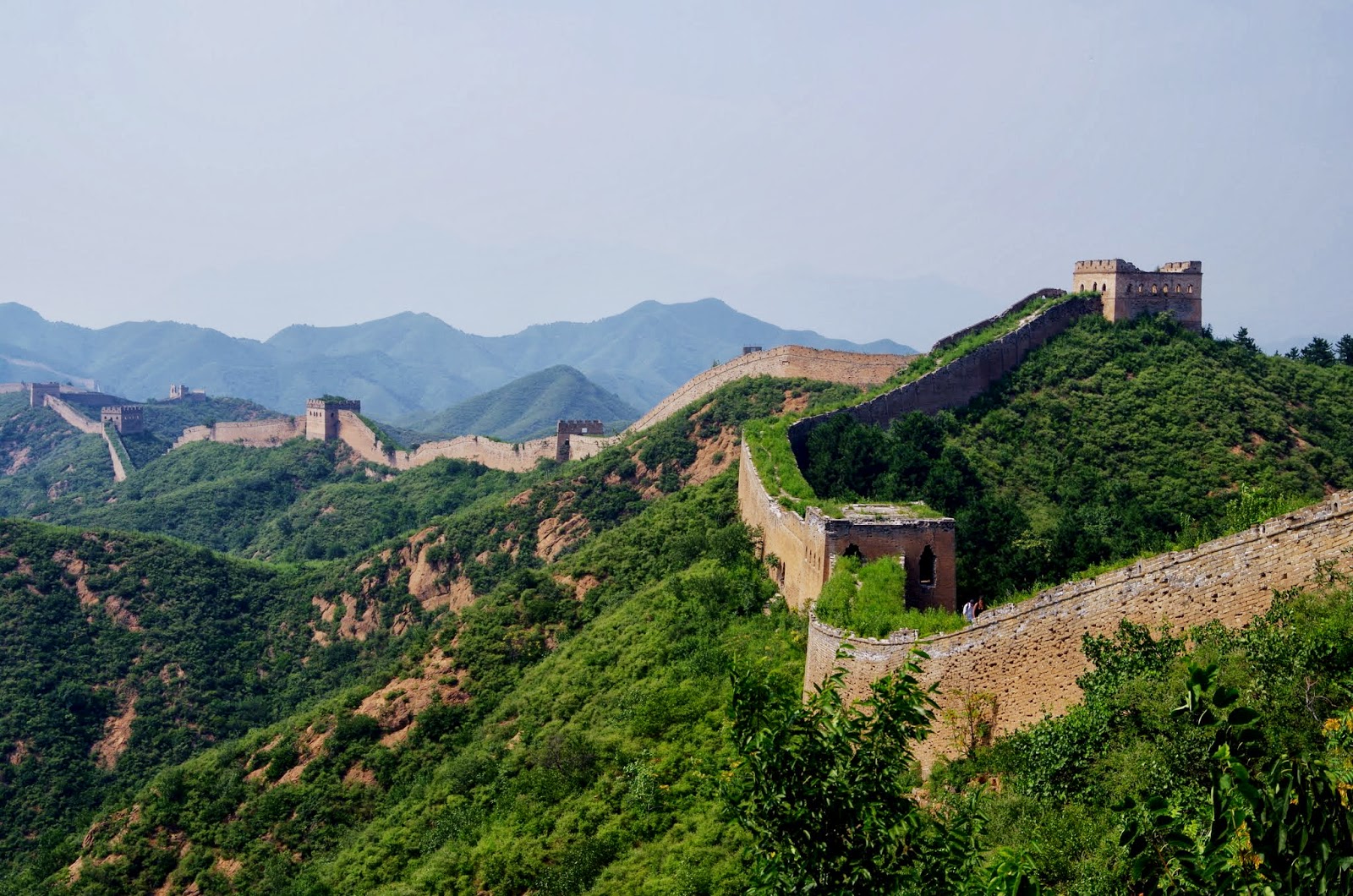
Back to me getting what I asked for. The Beijing Hikers took us out to Gubeikou and we hiked either 10 or 14 Kilometers to Jinshanling. A bit of geography, Beijing is a city and a province/municipality which is completely surrounded by Heibei Province. In Hebei Province alone, the wall runs for 2,000 kilometers, through more than 200 passes. The Jinshanling Great Wall lies in the mountainous area of Luanping County, Hebei Province, and has a total length of 10.5 kilometers. The Jinshanling Great Wall was first built in the sixth century during the Northern and Southern Dynasties (420-589). There are 67 watchtowers, all in different styles, some with ‘Nine Eyes’ and some with ‘Twenty Four Eyes’ at average intervals of 150 meters. The number of eyes a tower has refers generally to its scale, but more specifically to the number of windows it has. During the Ming Dynasty, General Qi Jiguang improved the structure at Jinshanling by making it both higher and denser. He also built double walls at strategic sections because the sloping hills at Jinshanling make it a vulnerable spot, easy to attack but difficult to defend. The walls are more solid, and the watchtowers taller, and more concentrated than other parts of the wall – makes great photos. Viewed from a distance, Jinshanling is seen as a giant dragon, curving its path over the mountain peaks.
It is number 2 on the map, and I hike from 1 to 2, and three has been closed down for a few years. The Immortal Valley is just north of where the Miyun Reservoir meets the wall. The hike I did in the rain, Jiankou to Mutianyu is numbers 4 and 5. The first section I went to is _(something I can't remember of find the name of, but know I wrote down somewhere)__. This coming weekend I am planning to go out to Yanqing with the Beijing Hikers. I think that is listed as a town in the northwest but I am not sure. A side note for any traveling to Beijing: the most visited location is Badaling so if you wish to see how many people can be jammed onto a historic artifact – go there, otherwise Mutianyu and Jinshanling are tourist accessible. Of course it should be noted that Regan, Nixion, and QEII all visited Badaling; Clinton ventured out to Jinshanling.

I hiked the 10 Kilometer route because I like to dawdle, and take photos, and talk, and generally just enjoy being out in nature away from the pollution of Beijing. Thus, by the time I reached the continuation point for the 14 Kilometers it was getting on 3pm, and STILL 35 degrees. I decided not to torture myself, and just go get a popsicle before sitting in the air conditioned bus.
This hike is remarkable because you spend over half your time on the ‘wild’ wall, but unlike Jiankou’s it is not overgrown with vegetation. You are winding your way along the spine of these hills, elevated over all of the trees and shrubs. On the day we went, there was not a cloud in the sky, and you could see well into the horizon; clearly seeing the wall snaking away into the great mountains in either direction. You really get a sense of what a sentry would see when pacing his length of the wall. On the south side there are paths, crop fields, and maybe a village a few kilometers off, but on the north, nothing but rolling hills that disappear into a blue haze.
We have to exit the wall and descend into ‘Spider Valley’ because the section ahead is a military restricted zone. Military restricted zones can mean many different things 1) they felt like it 2)it is dangerous to try and cross this section of the wall 3) things better left unsaid are hidden there 4) the section lies inside of a military base 5) no reason that makes much sense. Spider Valley is no longer filled with spiders, but apparently on the first few hikes you had to be careful not to get caught in a web. Personally, I felt right at home because when the spiders left, the farmers planted corn – and lots of it. The crop was just about ripe for harvesting when we wandered through, and gave me a nice craving for corn on the cob.
 |
| Definitly don't see that when looking out of cornfields in the Midwest, a baseball game with ghosts, maybe, looming stone wall ... that one was new. |
One of these industrious farmers noticed all of the crazy foreign hikers wandering through his cornfields trekking around the military restricted zone. He then realized that if he built a fence in front of the pass (read: hole in wall) that took you back onto the wall, all of those foreigners with more money than sense would have to walk right by his house. Don’t know what his house looked like before but now it has a bright red roof, beds for rent, cold drinks, and snacks for sale. And they China is Communist.
 |
| Straight forward capitalism at its best. |
 |
| The man himself, though I didn't see him move until the shade did. |
This detour of course means you are faced with a pretty steep hike back up to the wall where shade beckons ever so seductively. She doesn’t leave you unsatisfied either because once you crest that last step up into the leafy outcropping the Dragon of Jinshanling is before you.
 |
| Dragon of Jinshanling |
 |
| A closer view of that dragon. |
If you’re like me, after snapping dozens of photos you will eventually start ambling onwards. And when you see the watchtower that marks the end of the ‘wild’ and the beginning of the restored you start thinking of popsicles, toilets, and air-conditioning. Then, wham, you run straight into these guys.
 |
| I am not exactly sure what is in those sacks, but it resembled concreate and looked pretty damn heavy to be hauling around on you back down an unstable 300 year old staircase. |
Makes you reconsider your willingness to hike the 14 kilometers just to show you are as tough.
However, once you reach the guard tower you realize that was all a pipedream.
 |
| The living accomodations leave something lacking. |
You sit there, gazing out at Jinshanling and admit while these guys have a great view their accommodations leave much to be desired. I happily retreated down the mountain to the waiting comforts taking only pleasurable memories and fleeting impressions of the past.
Now my top ten photos:
 |
| This is the view from the watchtower where the workers were living, and selling us cold water. |
 |
| 360 of the dragon |
 |
| This is the staircase the workers were fixing up. |
 |
| Black and White for kicks, and some super over exposure. |
 |
| The 'wild' wall snaking back west into the high mountains. |
 |
| A sentry's view from the top. |
 |
| The eyes at 24 Eyes Tower |
 |
| The way we came following the spine of the hills. |
 |
| Why not build one really high pass there to start with? To slow down anyone trying to use the wall as a highway of course. |
 |
| Twisting away into the hills above the valley. Notice how close the guard towers are to each other. |
If you want to see more:
No comments:
Post a Comment